Elevation Certificate data plays a vital role in supporting tree preservation compliance, especially on sloped land. In Austin and similar jurisdictions, protected trees can be severely affected if elevation and grade changes are not properly measured and planned. This can lead to permit rejections, costly delays, and even fines. A certified elevation certificate helps property owners and developers show how site elevations relate to tree root zones and canopy areas, ensuring grading stays within allowed limits and avoiding unnecessary damage to valuable trees.
Understanding Tree Protection Requirements in Sloped Austin Parcels
The City of Austin enforces strict rules around protected trees, generally those with a diameter of 19 inches or more. When a parcel has a slope greater than 15%, those rules become even more complex. Cut-and-fill work, grading, and trenching all require special care around tree roots.
The city limits how much earth can be moved near trees depending on the slope. Elevation plays a direct role in calculating these limits, which is why it must be verified before work begins.
Elevation as a Control Factor for Grading and Tree Impact Zones
Elevation data shows how the land rises and falls around trees. This is important for understanding which areas are at risk during grading.
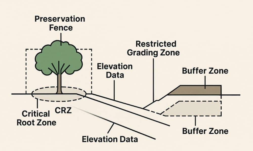
Elevation benchmarks help define:
- Where preservation fencing should be installed
- Which trees fall within restricted grading zones
- Where slope limits trigger additional protections
Even a small miscalculation in elevation can put a tree’s root zone in danger, leading to project complications later. Using a certified Elevation Certificate ensures accuracy when applying these benchmarks during site planning.
How Elevation Certificates Aid in Pre-Construction Tree Compliance
Before construction starts, an elevation certificate helps verify the vertical distance between tree bases and surrounding grade. This helps determine whether a plan stays within Austin’s tree protection rules.
It also helps map:
- Critical root zones (CRZs) in relation to building pads
- Driveway and utility alignments that may need rerouting
- Buffer zones that must remain undisturbed
This elevation data is often required in tree review forms and must be provided with permit applications involving protected trees.
Identifying High-Risk Encroachment Areas Before Site Work Begins
On sloped lots, elevation can change quickly over short distances. This makes it difficult to spot grading violations by eye. A certified elevation report helps identify risk areas early.
It can show:
- Where proposed grading may exceed city limits near a tree
- Potential foundation placements that interfere with root zones
- Encroachment zones that require design revisions
Spotting these problems before site work begins helps avoid code violations and costly redesigns.
Supporting Landscape Architects and Surveyors with Unified Site Data
When elevation data is certified, everyone on the design team works from the same starting point. Surveyors, arborists, and landscape architects can use this data to guide decisions around layout, drainage, and root protection.
A certified survey ensures that all elevation benchmarks and site details are accurate and legally recognized, reducing the risk of miscommunication and project delays.
Elevation benchmarks allow for:
- Overlaying tree protection zones on grading and drainage plans
- Creating accurate mitigation plans for impacted trees
- Submitting consistent, verifiable data during plan reviews
By using one trusted source of elevation data, teams stay aligned and avoid communication gaps.
Frequently Asked Questions
1. What is the purpose of an elevation certificate for tree protection?
It shows how the ground level relates to protected trees, helping you follow Austin’s grading limits near root zones.
2. When is this needed in the Austin permitting process?
You need it before submitting site plans that involve protected or heritage trees especially on sloped lots.
3. Who prepares the elevation certificate?
A licensed surveyor collects and certifies the elevation data.
4. Can I skip this if the trees look safe?
No. Visual judgment isn’t enough certified elevation data is required to confirm compliance with city standards.
5. How does this benefit my project long-term?
It reduces the risk of delays, avoids fines, and supports future development or resale with verified documentation.


