How To Find Your Property On FEMA’s Flood Insurance Rate Maps

What are FEMA flood maps?
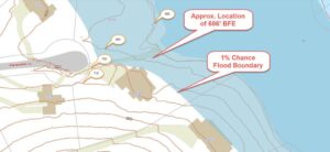
FEMA’s Flood Insurance Rate Maps (FIRMs) or just Flood Maps are provided after a flood risk assessment has been completed or updated for a community.  This study is known as a Flood Insurance Study.  The FIRM gives you the Base Flood Elevations (BFEs) and insurance risk zones in addition to floodplain boundaries.  The FIRM may also show a delineation of the regulatory floodway.

Once the “insurance risk zone”  (commonly referred to as the flood zone) is determined, actuarial rates, based on these risk zones, are then applied for newly constructed, substantially approved, and substantially damaged buildings.  FEMA uses these rates to determine the insurance rate you will pay for flood insurance

FEMA’s Digital Flood Maps

FEMA discontinued the production and distribution of paper flood maps in 2009 as part of its Digital Vision Initiative. This affected all the Flood Maps, boundary information, and study reports. However, clients can still view the products for free through their website or buy them in digital format.

To view these flood maps online, go to FEMA’s Map Service Center and key in your address (hi-lited area shown here) search for your home.  This will prompt you to then select the map that covers your area.  The Flood Maps are somewhat cumbersome to use online. It is best to go through the tutorial on the bottom right of the address search page for an easier and more effective use of the GIS map.

author avatar
Surveyor

More Posts

Flooded roadway with warning sign and construction crew illustrating the importance of proper detention pond design and stormwater drainage
civil engineering
Surveyor

How a Recent Crash Exposed Flaws in Detention Pond Design

A few days ago, news broke about a serious crash in a Texas highway construction zone. Multiple cars collided on a rainy morning, causing long traffic delays and plenty of frustration. It wasn’t just another highway story—it reminded everyone how connected detention pond design and safe road construction really are.

Read More »
Land surveyor site showing an open lot being reviewed for a due diligence survey before apartment redevelopment
alta survey
Surveyor

The New Demand for Due Diligence Survey After SB 840

A due diligence survey just became a much hotter topic in Grand Prairie. Thanks to a new Texas law, called Senate Bill 840 (SB 840), property owners and developers in the city are rethinking how they check a piece of land before moving ahead. In simple terms: when you’re buying

Read More »
Excavator and cranes working on a large civil engineering site under development for drainage and stormwater design
civil engineering
Surveyor

Stormwater Design Challenges in Large-Scale Site Development

When people in North Texas hear that H-E-B is finally coming to town, excitement spreads quickly. But in Sherman, this new retail megasite is more than a shopping milestone—it’s a major civil engineering project. In late September, the city council approved a $12 million plan to improve roads, utilities, and

Read More »
Water treatment plant expansion showing active flow, highlighting infrastructure upgrades that impact flood study and drainage requirements
civil engineering
Surveyor

Flood Study: $1.7B Water Upgrades Reshape Rules

Big changes are coming to Plano’s water system, and every developer, project manager, and civil engineer should pay attention. The North Texas Municipal Water District (NTMWD) recently approved a $1.7 billion capital program for 2026, and one of the headline projects is the Wylie Water Treatment Plant IV expansion, set

Read More »
Licensed surveyor measuring a home’s elevation for a flood elevation certificate
flood damage
Surveyor

Flood Elevation Survey: Why Every Homeowner Should Care

When the recent DFW flood alerts went out in late September, residents were reminded how quickly heavy rain can change daily life. Streets filled, creeks swelled, and neighbors worried about whether water would reach their homes. In moments like these, many people hear the term flood elevation certificate from their

Read More »
Surveyor using total station for boundary survey at a road construction site
boundary surveying
Surveyor

Boundary Survey Demand Rises as Projects Break Ground

If you live in Midland, you can see how busy the city has become. Roads are being widened, new subdivisions are taking shape, and utility crews are everywhere. At the same time, the oil and gas sector is facing fresh rules and tighter checks. With so much happening, one service

Read More »