Imagine owning a piece of land and then getting a serious offer out of nowhere. It happens more often now. The city keeps growing, and large companies are looking for space to build. Some of them want land for data centers, which need room, power, and the right location. Because of this, landowners are getting attention they did not expect. At first, it felt exciting. However, many sellers jump into talks too quickly. They focus on price before they truly understand their property. That is where an alta land survey becomes important. It helps you slow down, see the full picture, and make better decisions before you agree to anything. And when you take that step, it becomes much easier to understand what your land is really worth before selling, especially when buyers are looking at it for future development.
Why Frisco Landowners Are Getting More Offers
Frisco sits in a strong position in North Texas. It is close to major roads, growing neighborhoods, and business hubs. As a result, developers see it as a smart place to build.
At the same time, data centers are becoming more common. These projects need land that can support heavy use and future growth. Because of that, buyers are searching for the right parcels early and moving fast when they find them.
So, landowners may get calls or emails with serious offers. Sometimes, these offers come before the owner even thinks about selling. This can feel like a rare chance. Still, moving too fast can lead to problems later.
Why Rushing Into a Deal Can Cost You
At first glance, an offer may look strong. However, it may not reflect the real value of your land.
Buyers often make early offers based on limited information. Later, they study the property in more detail. Then, they may find issues that affect how they plan to use the land. Once that happens, they may try to lower the price.
Now the seller faces a hard choice. Accept less money or risk losing the deal.
On the other hand, if you understand your property from the start, you stay in control. You can stand by your price and avoid being pushed into changes. That is why it helps to prepare before any serious talks begin. Many landowners do this by getting an alta land survey before selling land, so they already know how their property will be seen when negotiations start.
How an ALTA Land Survey Helps You Understand Your Property
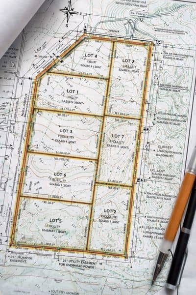
An alta land survey gives you a clear view of what you own. It shows how your land sits on the ground and how it can be used.
Many owners rely on old records or simple maps. However, those do not always reflect real conditions. Because of that, there can be gaps between what you believe and what exists.
With the right survey, you see your property in a more complete way. You understand how it fits into real-world development. You also see how a buyer might look at it.
This matters because buyers do not just see land. They see how they can build on it. If your land works well for their plans, its value increases. If not, they may adjust their offer.
So, knowing your land early helps you stay prepared.
Why Knowing First Gives You an Advantage
In many deals, the buyer leads the process. They study the property and bring up issues. Then, they use those findings during negotiation.
However, when you already have an alta land survey, the situation changes. You know your property before the buyer begins their review. Because of that, you can guide the conversation instead of reacting to it.
This makes a big difference. You answer questions with confidence. You explain your property clearly. And you avoid last-minute surprises that can affect the deal.
At the same time, buyers respect sellers who come prepared. It shows that you understand the value of your land and that you take the process seriously.
Why Data Center Projects Raise the Stakes
Not every project places the same demands on land. Data centers require a higher level of certainty. These buyers look closely at every detail before they commit.
They want to know if the site can support their plans without major problems. They want to move forward without delays. Because of that, they take time to review the property in depth.
If they find something late in the process, they may pause the deal or ask for changes. That can affect both the timeline and the price.
However, if you already understand your land, the process becomes smoother. You reduce unknowns and make the deal easier to move forward. This can help both sides feel more confident.
A Better Way to Prepare Before Selling
Many landowners wait until they receive an offer before they start preparing. However, that often leads to rushed decisions.
Instead, it helps to take a step back and learn about your property first. This gives you time to think clearly and plan your next move.
When you prepare early, you do not feel pressured. You can review offers carefully and choose what works best for you. You also avoid reacting to new information during the deal.
In the end, preparation gives you more control over both price and timing.
Work With a Licensed Land Surveyor Who Understands Frisco
Choosing the right professional also matters. A licensed land surveyor who knows the Frisco area can help you understand your land in a real-world way.
They see how local conditions affect development. They also understand how buyers view land in this market. Because of that, they can give you better insight, not just basic information.
This can help you prepare for serious conversations and make stronger decisions when offers come in.
Final Thoughts
Frisco continues to grow, and more landowners will face decisions about selling. While strong offers can feel exciting, they also come with risk if you move too fast.
Before you agree to anything, take time to understand your property. Know how it fits into future development. And make sure you see the full picture before entering negotiations.
An alta land survey helps you do exactly that. It gives you clarity, confidence, and a stronger position when it matters most.
So, if a buyer approaches you, do not rush. Step back, get the right information, and make sure you move forward on your terms.