Houston property owners are starting to run into a new kind of problem. It’s not always about building something new. Instead, it often comes down to proving what already exists on the property.
Recent stormwater discussions around the Houston area show how things are changing. Fees and reviews now depend on how much hard surface a site has, including parking lots, roofs, and paved areas. At the same time, many owners don’t have clear, up-to-date records of their property.
Older plans no longer match real conditions. Surfaces shift, drainage paths change, and small updates go unrecorded over time. Because of that, property data can quickly fall out of sync with what’s actually on-site.
That’s where tools like lidar mapping in Houston are starting to come into the picture, helping property owners get a clear, current view of their site.
Why Property Records Fall Behind
Most commercial sites in Houston were built years ago. Some even decades ago. Over time, small changes add up.
A parking lot gets resurfaced. A building gets expanded. Drainage paths get adjusted during repairs. None of this gets fully updated in official records.
So when someone asks for documentation, the owner ends up guessing.
That creates problems fast.
You may show an old plan, but it doesn’t reflect what’s on the ground. That can lead to delays, confusion, or even extra costs.
What Property Owners Are Being Asked to Show
In many cases, owners now need to show clear details about their site. That usually means having enough information to clearly document your property’s current surface conditions instead of relying on old plans or guesswork.
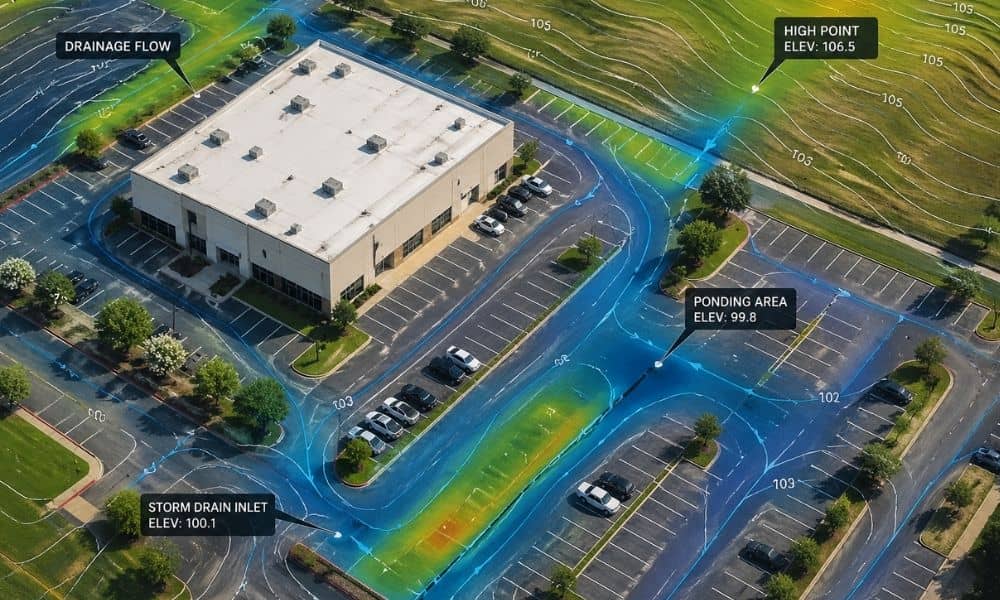
It helps to know how much of the property is paved, where water flows during rain, and which areas tend to collect it. You also need a clear view of any drainage features already in place.
This isn’t about design. It’s about having proof you can stand behind.
Without solid data, someone else ends up filling in the gaps, and that rarely works in your favor.
Why Basic Surveys Don’t Always Help
Traditional surveys still matter. But they don’t always capture enough detail for today’s needs.
A standard survey may miss small elevation changes. It may not show how water actually moves across a surface. It also takes time to update, and many sites never get re-surveyed after changes.
That leaves gaps.
Those gaps become a problem when decisions depend on accurate site data.
How LiDAR Mapping Works on Real Properties
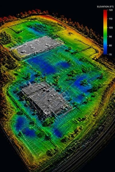
LiDAR uses laser scanning to measure the surface of your property. It collects thousands of data points across the entire site.
That data turns into a detailed surface model.
It shows the ground exactly as it is today.
Not five years ago. Not based on a plan. Right now.
This level of detail helps you see things that are easy to miss with basic measurements.
What LiDAR Mapping Can Actually Show
This is where it becomes useful for property owners.
LiDAR mapping can document:
- The slope of parking lots
- Where water flows after rain
- Low spots where water collects
- Changes in grading over time
- Roof drainage discharge areas
- Edges between paved and unpaved surfaces
These are the exact details people look for when reviewing drainage conditions.
Instead of guessing, you have clear data.
Real Situations Where This Matters
This kind of documentation becomes important in everyday situations.
For example:
You own a commercial property and get asked for updated site data. Your old plans don’t match what’s on-site anymore.
Or you’re planning improvements, and someone needs to understand how water moves across your property before work starts.
Or you’re buying land, and you want to know what’s really there before making a decision.
In all of these cases, clear documentation saves time and stress.
Why Accurate Data Helps You Stay in Control
When your property data is unclear, you lose control of the conversation.
Other people decide what your site looks like. That can lead to wrong assumptions.
Accurate LiDAR data changes that.
You can show exactly what exists. You can explain how your site works. You can answer questions without guessing.
That makes a big difference during reviews, planning, or discussions about site conditions.
When It Makes Sense to Use LiDAR Mapping
You don’t need LiDAR for every situation. But there are times when it makes sense.
Consider it when:
- Your site plans are outdated
- The property has changed over time
- You need clear surface data
- You want to avoid delays during reviews
- You’re dealing with a large or complex site
In these cases, having accurate data upfront saves more time than trying to fix problems later.
Why This Is Becoming More Common in Houston
Houston continues to grow. With that growth comes more attention on how land is used.
That includes drainage, surface coverage, and site conditions.
As a result, property owners are being asked for better documentation.
This shift isn’t going away. It’s becoming part of how properties are reviewed and managed.
A Smarter Way to Stay Prepared
You don’t want to wait until someone asks for proof.
By that point, you’re already reacting.
LiDAR mapping gives you a clear picture of your property before questions come up. It helps you stay prepared and avoid last-minute problems.
If you’re not sure what your property records actually show today, it may be time to take a closer look.